
Mason County, West Virginia Map v 4.0

0/5,
0
Stimmen
Letzte Aktualisierung
aktuellste
Version
v 4.0
vor 10 Monaten
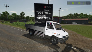
This is West Virginia's Mason County! There may be some updates made since this is my first map. Enjoy yourself and share your thoughts with me. This pertains to FS25.
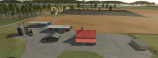
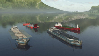
A huge sheep/goat barn, a poultry farm with 5,000 hens, and a 1000-head cow farm are all located on the map! Additionally, there are other sizable logging areas with plenty of terrain variation to test your logging prowess. All logs may be chopped and processed by bunchers and processors. One area in particular is 1000 acres. You will come to the logging base at the summit. Alternatively, you may farm or log the other side of the river by using the boat. Grain elevators, sawmills, carpenters, spinneries, tailors, restaurants, BGAs, canning factories, and warehouses are all present.
Changelog: +
Update: V2
To keep people from driving off course, a boundary was added around the map.
fixed sawmill unloading and selling area.
Terrain and flora decorations were added.
Mis. decor was added.
Update V3
At the dealership, the decor equipment was fixed.
Update #4
Animal barns that are fixed are not appearing.
Collectibles were added.
Additional rocks that may be destroyed
Farmland and field errors have been fixed.
Numerous field sizes and numbers were modified.
Pig farm was added.
Compost mod that wasn't functioning was removed.
Map decoration was added.
The arrangement of the chicken farm was altered.
Source: Father_farmer
This is West Virginia's Mason County! There may be some updates made since this is my first map. Enjoy yourself and share your thoughts with me. This pertains to FS25.
A huge sheep/goat barn, a poultry farm with 5,000 hens, and a 1000-head cow farm are all located on the map! Additionally, there are other sizable logging areas with plenty of terrain variation to test your logging prowess. All logs may be chopped and processed by bunchers and processors. One area in particular is 1000 acres. You will come to the logging base at the summit. Alternatively, you may farm or log the other side of the river by using the boat. Grain elevators, sawmills, carpenters, spinneries, tailors, restaurants, BGAs, canning factories, and warehouses are all present.
Source: Father_farmer
Dateien der neuesten Version herunterladen
Version: v 4.0Aktualisiert: vor 10 Monaten
Gesamtgröße: 507.7 MB FS25_westvirginia_fs25planet.zip direct herunterladen · 507.7 MB · hinzugefügt. vor 10 Monaten
Sie könnten auch mögen »

_fs25planet.jpg)


0 Kommentare
Es sind noch keine Kommentare vorhanden. Seien Sie der Erste, der kommentiert!